
INTELLECTUAL CONCEPTS PORTFOLIO
Intellectual Concepts, a woman-owned Professional Services firm based in Atlanta, GA, specializes in consulting for mobility, engineering, and environmental public health. In the summer of 2023, I had the opportunity to join as one of the firm’s first interns, alongside another student from the University of Illinois, as part of their inaugural internship program.
Our primary project involved creating pollution maps of Cancer Alley for the Deep South Center for Environmental Justice. This region, stretching along the Mississippi River in southern Louisiana, encompasses roughly eight parishes with cancer rates significantly higher than the national average—a disparity widely attributed to the dense concentration of petrochemical refineries in the area.
Pollution Mapping in the Cancer Alley


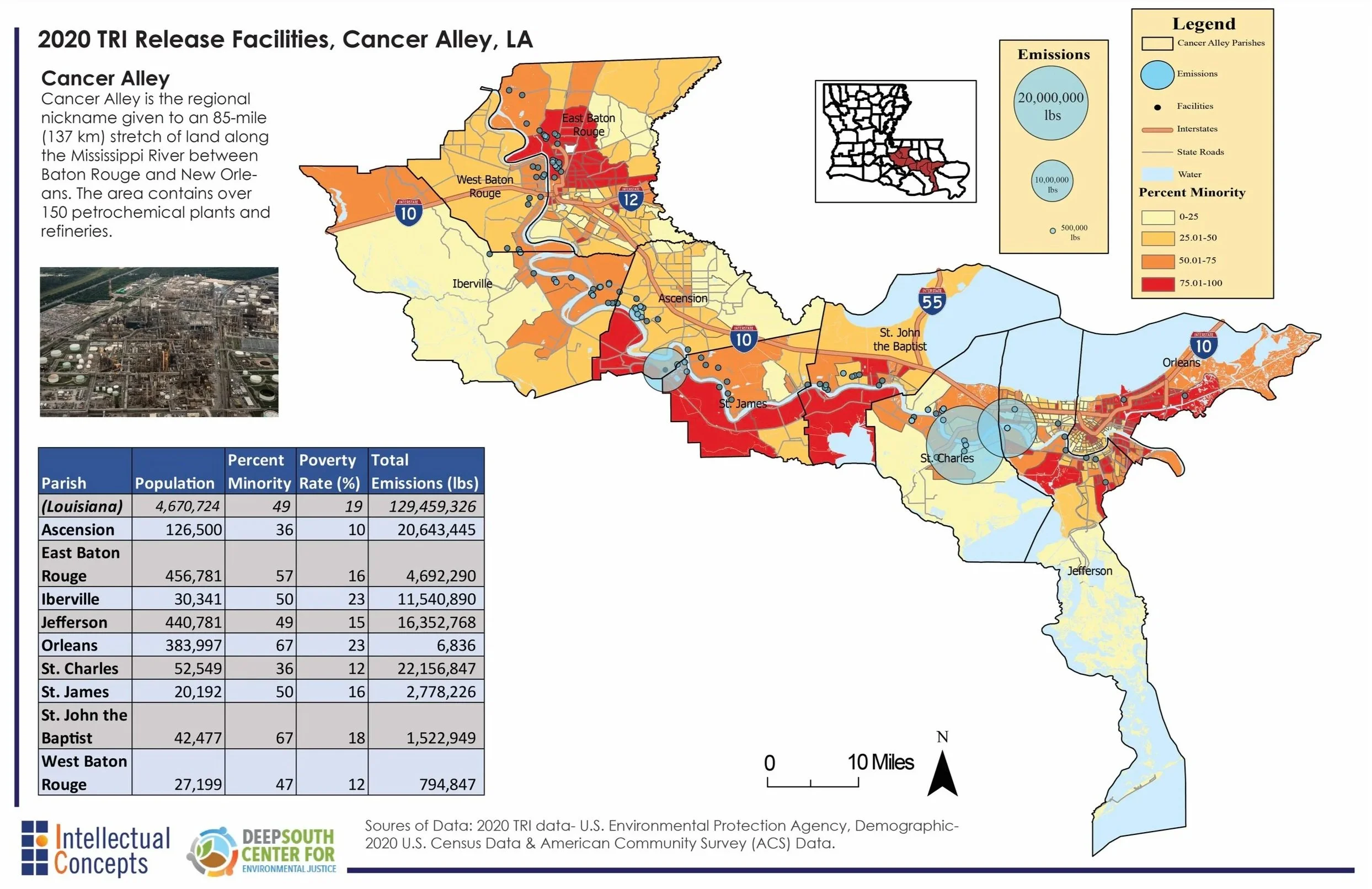
Overlaying demographic data by U.S. Census block, I was able to portray variables such as poverty rates and percent minority and their spatial relationship to the pollution rates of the highest emitting petrochemical plants in the region.
The top map shows the location of petrochemical plants, the total emissions that each facility emits, and the the amount of emissions emitted in each of the eight parishes within the past five years. In addition, the rate of minority residents in each census tract is illustrated, with a moderate to strong correlation between the location of petrochemical plants and the rate of majority minority census tracts.
The middle map shows the poverty rate of census tracts overlayed with the rate of emissions from petrochemical plants, with the highest emitting petrochemical plants often located in are near the tracts with higher poverty rates.
The bottom map illustrates the minority percentage of census tracts with the rate of emissions from petrochemical plants overlayed, similarly illustrating how the highest emitting petrochemical plants are often in or near census tracts with a higher percentage of minorities.
The consistent spatial relationship between pollution sources and marginalized communities creates compounding crises - from elevated cancer risks to depressed property values. This project demonstrated how technical analysis can become a powerful tool for environmental justice, transforming complex datasets into clear visual arguments for change. The work has since been utilized by the Deep South Center for Environmental Justice and has fundamentally shaped my approach to equitable planning - where data science must serve not just analytical purposes, but for frontline communities bearing the heaviest environmental burdens.